7.8.3. NDFD
For decades some of the finest weather forecasts in the world were captured in the weather charts produced by the NOAA Ocean Prediction Center. Forecasters pored over the very best available model, buoy, ship of opportunity and satellite data, combined this with their years of forecasting experience and local knowledge and produced weather charts every ocean mariner learned to rely upon. Until the 1990's, these charts were only available via weatherfax broadcast and mariners went through reams of chart paper and hours of time tuning their weather fax radios to receive the data. With the growth of the Internet in the late 1990s, chart distribution expanded to this medium and OCENS WeatherStation was the first such service to make them available to satellite phone users.
For years, NOAA has been working on the next step in this evolution. To move the static OPC and NHC weather charts and their classic picture file formats into GRIB data so these data become all that more relevant to the at-sea user now dependent on satellite phones, electronic charting and so many other components of the electronic ship. The first realization of these efforts is that which is now available in the NDFD data just released in GE Plus. NDFD data preserve all the human intelligence and local knowledge put into the OPC and NHC charts but make this information available in the form of GRIBs which can be animated, layered and closely analyzed.
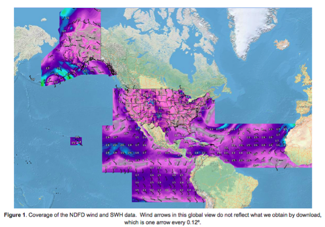
Presently, only wind and significant wave height data is available in the NDFD form. Furthermore, the geographic coverage of the NDFD GRIB data is, to say the least, disjointed. A map of that coverage is presented below. NOAA is working to expand both the coverage and the type of data available as NDFD GRIBs in the next few years.

NDFD data in SAGA Explorer is available at two resolutions. NDFD Fast data is at 0.25 degree (4 data points per degree) while NDFD HiRes is 0.125 degree data or 8 data points per degree. As an example of the difference this makes on download times, a 10x10 NDFD HiRes wind GRIB will take just under 4 Iridium minutes to download. The same 10x10 area in NDFD Fast data consumes about 1.5 minutes of Iridium airtime.
NDFD data are available for forecast durations of 1 through 6 days inside of the Ocean Wind and Ocean Wave sections of SAGA Explorer.