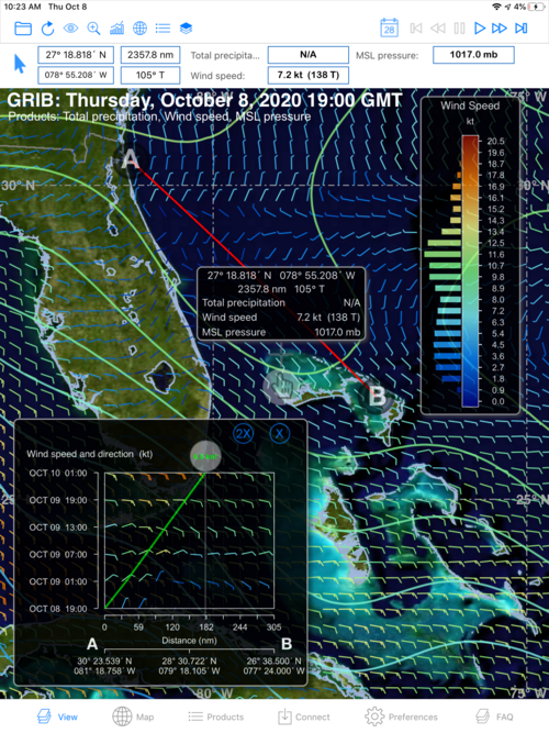
4.1.3. Trip Planner
Trip Planner is combining the information in Route Finder with that in the Time Profile to produce a quick look at the optimum route to your destination.

Like its siblings, the first thing to happen when you select Trip Planner is that a draft A-B route is drawn on your background weather map. You can grab A or B and move them to the actual start and end points of your upcoming voyage.
Knowing your start and end, A-B, locations, SAGA plots distance from your starting point on the Trip Planner graph's X axis and departure dates and times on the Y axis, then adds two adjustable, sliding 'bubbles'. One bubble moves up and down along the departure data axis to let you change your departure date. A second bubble moves along the top of your graph and calculates boat speed.
Notice that if you move the departure bubble up the date axis to later departure dates, the boat speed bubble moves left and speed posted inside that bubble does not change. As such, if you are departing later and moving at the same speed, you will not get as far along the 'distance from start'.
Of course, you may want to adjust your boat speed once you have changed the departure date. Do so by dragging the boat speed bubble right (or left). Note a transparent dropline to the X, distance-from-start, axis moves with you when you move the boat speed bubble. This allows you to easily see how far along your voyage route you will get at that boat speed and with that departure date.
How would I use the Trip Planner?
Start by looking at the field of weather data plotted inside of the Trip Planner graph. Are there obvious disturbances or weather events and wind conditions you would like to avoid in that field of data? Can you avoid them by changing your departure date or keeping a departure date and traveling slower or faster (if possible)? Trip Planner lets you evaluate and answer that question. It also lets you quickly reassess that conclusion as the model updates at each of its cycles.
Alternatively, you know how fast you are likely to sail or motor. Adjust the boat speed icon to that speed, then move the departure date bubble to evaluate alternative departure dates relative to the weather forecasted along and around your A-B route. This may reveal a better departure date or one which provides smoother or more comfortable sailing. Or maybe a departure date that allows you to take advantage of optimum wind conditions and faster sailing for your trip. By moving the line around, in effect you can search for a route that offers the best weather conditions for you and your sailing goals.